
(e.g. yourname@email.com)

Forgot Password?

    Digital Visual Information Distribution System Logo

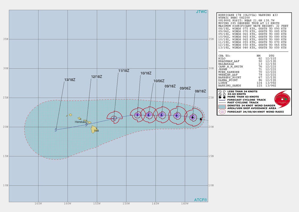
    Joint Typhoon Warning Center TC Warning Center Graphic - Olivia #33 [Image 1 of 2]

    Issued by: on

    VIRIN:
    Date Created:
    City:
    State:
    Country:
    This is a JTWC (Joint Typhoon Warning Center) tropical cyclone track forecast chart for Hurricane 17E (Olivia), Warning #33, dated 08/1800Z. The storm is positioned near 21.6°N 138.7°W, moving west at 285 degrees true at 13 knots with maximum winds of 75 knots. The forecast track shows the hurricane moving westward toward the Hawaiian Islands over the following several days.

    UNITED STATES

    09.08.2018

    Courtesy Photo

    U.S. Coast Guard Oceania

    Hurricane 17E (Olivia) Warning Graphic #33 Issued Sept. 8, 2018, at 2100Z from the Joint Typhoon Warning Center in Stennis Space Center, Mississippi. Olivia is a dangerous storm threatening the Main Hawaiian Islands. (U.S. Navy graphic)

    IMAGE INFO

    Date Taken: 09.08.2018
    Date Posted: 09.08.2018 21:28
    Photo ID: 4710048
    VIRIN: 180908-G-G0214-1002
    Resolution: 1540x1094
    Size: 820.53 KB
    Location: US

    Web Views: 136
    Downloads: 3

    PUBLIC DOMAIN




