
(e.g. yourname@email.com)

Forgot Password?

    Digital Visual Information Distribution System Logo

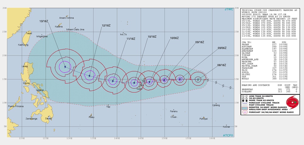
    Joint Typhoon Warning Center TC Warning Graphic - Mangkhut #08 [Image 2 of 2]

    Issued by: on

    VIRIN:
    Date Created:
    City:
    State:
    Country:
    This is a JTWC (Joint Typhoon Warning Center) tropical cyclone track forecast chart for Tropical Storm 26W (Mangkhut), Warning #8. The chart displays the storm's projected path moving westward across the Western Pacific Ocean toward the Philippines, with forecast positions marked at 6-hour intervals from 08/18Z through 13/18Z. Wind radii circles (34, 50, and 64 knots) are shown at each forecast position, indicating the storm's expected intensification.

    Tropical Storm 26W (Mangkhut) Warning Graphic #08 Issued Sept. 8, 2018, at 2100Z from the Joint Typhoon Warning Center in Stennis Space Center, Mississippi. Mangkhut is a dangerous storm threatening Guam and the Northern Mariana Islands. (U.S. Navy graphic)

    IMAGE INFO

    Date Taken: 09.08.2018
    Date Posted: 09.08.2018 21:28
    Photo ID: 4710043
    VIRIN: 180908-G-GO214-1003
    Resolution: 1978x948
    Size: 1.32 MB
    Location: US

    Web Views: 273
    Downloads: 6

    PUBLIC DOMAIN




