
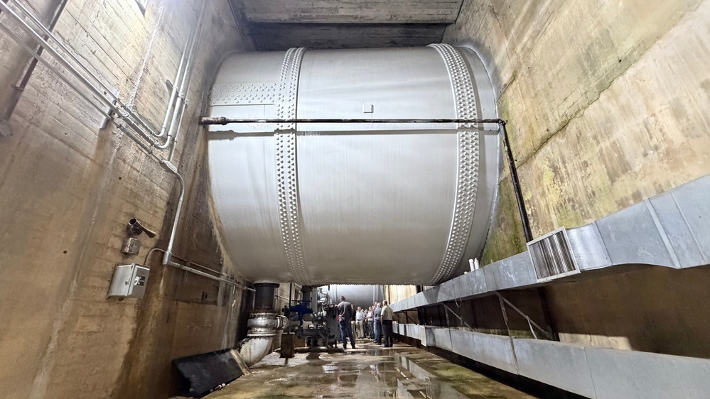
Photo By Leon Roberts | Participants of a dam safety tabletop exercise tour the powerhouse and penstocks Aug....... read more read more
JAMESTOWN, Ky. (Aug. 26, 2026) – What would happen if Wolf Creek Dam faced a massive flood or a critical security breach? Last week, federal, state, and local emergency officials converged in Kentucky to answer that very question, simulating a unified response to a high-stakes, dual-threat crisis.
Hosted every five years by the U.S. Army Corps of Engineers Nashville District, the tabletop exercise ensures emergency managers and stakeholders synchronize their actions and test operational readiness through the Corps of Engineers’ Emergency Action Plan.
Representatives from USACE, the National Weather Service, the Federal Bureau of Investigation, and the U.S. Fish and Wildlife Service attended the Aug. 20 event. They were joined by emergency managers from Kentucky (Russell, Cumberland, and Pulaski counties) and Tennessee (Jackson County), alongside the Tennessee Regional Upper Cumberland Healthcare Coalition.
“This is the low-stress environment to learn and ask questions,” said Lt. Col. Guillermo Guandique, Nashville District commander, in addressing participants at Wolf Creek Dam. “If something is really happening and something is going on, your experience in this exercise will prove beneficial.”
Participants became more familiar with each other’s capabilities and the likely timeline that each agency would respond. They learned about Corps of Engineers’ responsibilities, early-detection procedures for structural anomalies, and communication protocols used to notify emergency management agencies of a potential or imminent dam failure.
Simulating the scenarios
Brad Long, Nashville District’s Dam Safety Program manager, led exercise discussions, provided instructions, and encouraged participants to provide input as each scenario unfolded.
The first scenario focused on a severe high-water event. To understand the stakes, participants reviewed the sheer scale of Wolf Creek Dam. Completed in 1952 for flood control and hydroelectric power, the concrete-gravity and earth-fill structure stands 258 feet high and spans over a mile. It holds back the 101-mile-long Lake Cumberland—providing a massive storage capacity of over 6 million acre-feet.
David Bogema, Nashville District’s Water Management Section chief, explained how critical the dam is during heavy rainfall and snowmelt, especially as part of the 10-dam system in the Cumberland River Basin. “During heavy rains, our primary job shifts entirely to flood risk management. This means we may temporarily hold back water to protect downstream properties," Bogema said. "Water managers hold and release water through the dam to reduce flood risks, support safe navigation, and we work to keep the public informed as conditions evolve.”
Mapping the risk
During the high-water simulation, Long highlighted a crucial visual tool for the emergency managers: Inundation Maps. Rather than leaving these maps as an afterthought, agencies actively use them to design realistic evacuation routes.
These maps feature a colored overlay that highlights how far water is expected to extend beyond normal banks during massive releases or a structural failure. They allow leaders to identify exactly who and what lies in a potential flood path.(Note: The public can view these maps by searching for "Wolf Creek Dam" on the National Inventory of Dams portal athttps://www.google.com/url?q=https%3A%2F%2Fnid.sec.usace.army.miland enabling the "Inundation Layers").
The exercise then pivoted to a second, more sinister scenario: a simulated sabotage. This human-caused threat required a rapid shift in tactics, incorporating law enforcement intervention, early-detection procedures for structural anomalies, and strict communication protocols.
Building relationships for real emergencies
By the conclusion of the tabletop exercise, participants had a much clearer understanding of each agency’s capabilities and response timelines. The feedback submitted will directly inform updates to the Emergency Action Plan, contact lists, and communication objectives.
“The tabletop exercise was a great opportunity to test the effectiveness of notification procedures... and communicate lessons learned from the simulated exercises so we’re prepared in the event of an actual emergency,” Long noted. “This critical interaction helped us develop informal relationships and to communicate openly.”
Participants also toured Wolf Creek Dam to familiarize themselves with its layout and hydropower mission—valuable geographic knowledge if a crisis ever strikes.
For Lt. Chris King of the Kentucky Fish and Wildlife Service, the chance to interact face-to-face was just as important as the simulation itself.
“We learn through repetition,” King said. “Practice does make perfect… networking is the key.”
The public can obtain news, updates and information from the U.S. Army Corps of Engineers Nashville District on the district’s website athttps://www.lrd.usace.army.mil/About/Districts/Nashville-District/, on Facebook athttp://www.facebook.com/nashvillecorpsand on X (formerly Twitter) athttp://www.x.com/nashvillecorps. Follow us on LinkedIn for the latest Nashville District employment and contracting opportunities athttps://www.linkedin.com/company/u-s-army-corps-of-engineers-nashville-district.
| Date Taken: | 08.26.2026 |
| Date Posted: | 08.26.2026 12:26 |
| Story ID: | 573256 |
| Location: | JAMESTOWN, KENTUCKY, US |
| Web Views: | 21 |
| Downloads: | 0 |

This work, Endgame of Wolf Creek Dam emergency simulation is readiness, by Leon Roberts, identified by DVIDS, must comply with the restrictions shown on https://www.dvidshub.net/about/copyright.


No keywords found.





