
(e.g. yourname@email.com)

Forgot Password?

    Digital Visual Information Distribution System Logo

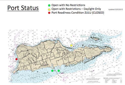
    Port openings around Puerto Rico, U.S. Virgin Islands post Hurricane Irma [Image 4 of 4]

    Issued by: on

    VIRIN:
    Date Created:
    City:
    State:
    Country:
    This is a nautical chart of the U.S. Virgin Islands showing port status as of September 9, 2017, likely in the context of Hurricane Irma response. The map uses color-coded dots to indicate the operational status of various ports across the islands. One port is closed (red/ZULU condition), one is open with daylight-only restrictions (yellow), and two are fully open with no restrictions (green).

    SAN JUAN, PUERTO RICO

    09.10.2017

    Photo by Petty Officer 2nd Class Jonathan Lally 

    U.S. Coast Guard Southeast     

    The Coast Guard Sector San Juan Incident Command Post and port assessment teams release updated port openings, closures and port restrictions post Hurricane Irma, Sunday, Sept. 10, 2017. U.S. Coast Guard illustration.

    IMAGE INFO

    Date Taken: 09.10.2017
    Date Posted: 09.10.2017 14:18
    Photo ID: 3752366
    VIRIN: 170910-G-G0101-1008
    Resolution: 504x343
    Size: 155.93 KB
    Location: SAN JUAN, PR

    Web Views: 116
    Downloads: 6

    PUBLIC DOMAIN




