
(e.g. yourname@email.com)

Forgot Password?

    Digital Visual Information Distribution System Logo

    Kailua Security Zone OUTREACH Illustration

    Issued by: on

    VIRIN:
    Date Created:
    City:
    State:
    Country:
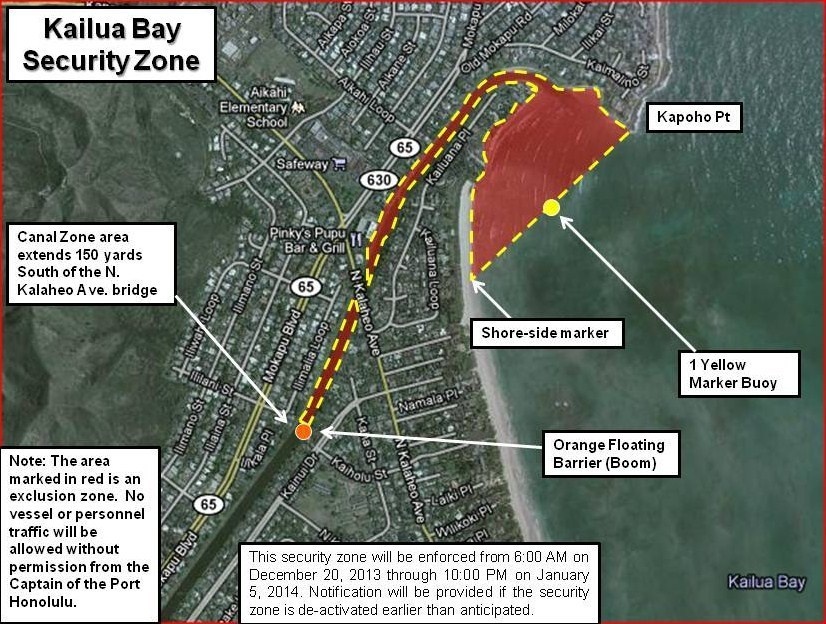
    This is an official aerial map of the Kailua Bay Security Zone in Hawaii, overlaid on a satellite image. The map delineates a restricted exclusion zone (marked in red) near Kapoho Point, enforced from December 20, 2013 through January 5, 2014. The zone includes physical markers such as an orange floating barrier (boom), a yellow marker buoy, and shore-side markers, with no vessel or personnel traffic permitted without authorization from the Captain of the Port Honolulu.

    Pictured is the Kailua Security Zone OUTREACH Illustration.

    IMAGE INFO

    Date Taken: 12.16.2013
    Date Posted: 12.16.2013 14:20
    Photo ID: 1138414
    VIRIN: 131216-G-XD768-001
    Resolution: 826x624
    Size: 194.62 KB
    Location: HAWAII, US

    Web Views: 1,299
    Downloads: 12

    PUBLIC DOMAIN




