When the Water Rises – A Lakes’ Purpose
FORT WORTH, TX — On a calm day, a U.S. Army Corps of Engineers’ lake can look like a permanent part of the landscape. Boats move across the water, anglers line the shoreline and visitors enjoy campgrounds and beaches. But the water level is anything but static.
Behind the scenes, hydrologists, engineers and lake personnel monitor rainfall, river flows, weather forecasts and lake elevations. A USACE lake is designed to hold water at different levels for different purposes, and as the lake level falls or rises, the mission of the lake can change dramatically.
From a lake below conservation pool to one storing floodwaters and, in extreme conditions, approaching a spillway or the top of the dam, every inch of elevation tells part of the story.
Below Conservation Pool: A Lake with Room to Rise When a lake is below its conservation pool, visitors may notice changes along the shoreline.
Boat ramps may become difficult to use or even close. Shorelines can extend farther into the lake. Islands and points that are normally underwater may emerge. Some boat docks may become unusable in shallow water, while recreational access and navigation can become more challenging.
Below the water's surface, however, the lake is doing exactly what it was designed to do: store water.
A USACE lake is divided into storage zones, or "pools," established for different purposes. Conservation storage generally supports authorized purposes such as water supply, recreation, environmental needs, hydropower or other project-specific missions. Flood storage is reserved to capture runoff from storms and reduce flooding downstream.
As water levels remain below conservation pool, the lake has available storage. Depending on the lake's water control plan, inflows, downstream conditions and authorized purposes, releases may be adjusted to manage the lake toward its operational objectives.
Every USACE lake is different. Its exact operating rules are established in project-specific water control plans, meaning there is no single release formula that applies to every lake.
Reaching Conservation Pool: The Lake's Normal Operating Target As the water rises, it eventually reaches the top of conservation pool, which is considered the lake's normal or target operating level.
At this point, the lake is generally at the level intended to support its authorized conservation purposes. For visitors, this may mean boat ramps are more accessible, shoreline facilities are connected to the water, and recreational areas operate under normal conditions.
“After remaining below conservation pool for more than four years, Canyon Lake experienced a remarkable turnaround,” said Brett Mazey, Lake Manager at Fort Worth District’s Canyon Lake. “One persistent storm system moving across the Guadalupe River watershed produced enough rainfall to raise the lake more than 21 feet in just five days, bringing the lake back to approximately 910 feet mean sea level, essentially returning the reservoir to conservation pool in a matter of days. The July 2026 event is comparable to the 1978 flood.”
But reaching conservation pool does not mean the lake is "full."
Above the conservation pool is storage specifically reserved for floodwaters. The amount of available flood storage varies from lake to lake and can represent an enormous volume of water held back to reduce flood risks downstream. USACE water management systems distinguish conservation storage from flood storage for this reason: a lake can be above its normal pool and still have substantial capacity remaining.
Into the Flood Pool: The Lake Goes to Work Heavy rainfall across a watershed can send enormous amounts of water toward a lake.
When inflow exceeds the amount of water being released, the lake begins to rise. Once the water moves above conservation pool, the lake enters its flood storage zone.
This is when one of the lake's most important missions becomes visible.
Instead of allowing the incoming runoff to continue immediately downstream, the lake stores a portion of that water. By temporarily holding floodwater, the lake can reduce downstream flows and help lower flood stages at communities, roads, bridges and other downstream infrastructure.
The lake does not stop the flood. It manages it.
“Water moves quickly during intense storms, and Texas has a documented history of extreme rainfall events dating from historical world records to recent severe weather,” said Simeon Benson, Acting Chief of Water Management for the Fort Worth District. “To manage these surges, our Water Management team continuously tracks NOAA radar feeds and USGS stream gages. This real-time monitoring provides the critical data needed to regulate reservoir releases and minimize downstream flooding.”
Hydrologists continually evaluate conditions upstream and downstream. They consider how much water enters the lake, how quickly the pool is rising, weather forecasts, conditions downstream and the operating rules established for that lake.
Releases may increase as conditions change, but those decisions must account for the entire river system. Releasing too much water too quickly can worsen flooding downstream. Holding too much water can cause the lake itself to rise higher.
Water management is a balancing act — using the storage built into the lake to reduce flood risks while safely managing water through the entire system. USACE water control manuals establish project-specific procedures for making those decisions.
The Higher the Water, the More Changes As a lake rises through the flood pool, the changes can become increasingly noticeable.
Parks and recreation areas near the shoreline may begin to close. Roads can be inundated. Boat ramps, campgrounds and day-use areas may become inaccessible. Trees, picnic areas and facilities normally located well above the water can find themselves surrounded by it.
For lake personnel, operations shift as well.
Personnel may increase inspections and monitoring. Engineers and water managers closely track pool elevations and inflows. Emergency management partners and downstream communities may receive updated information as conditions evolve.
The amount of available flood storage becomes increasingly important.
“Our Fort Worth District multiple-purpose reservoirs were authorized and constructed to protect downstream from flooding, provide water supply, provide recreation and natural resources management and in a few cases, for hydropower generation,” said Tim MacAllister, Chief of Operations Division for the Fort Worth District. “While all of our missions are important, the protection of downstream areas from flooding events takes precedence over all other missions. I understand the frustrations when park closures due to flooding events occur, but our first and foremost mission is to protect lives and property downstream.”
A lake's flood pool is not simply empty space waiting to be filled. It is a carefully designed part of the overall flood risk management system.
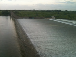
Approaching the Spillway Depending on the design of the dam, a lake may have a spillway that begins passing water when the lake reaches a specific elevation.
Some spillways are ungated. In those cases, water begins flowing over the spillway once the lake rises above the spillway crest.
Other projects have gated spillways. Gates can be operated according to the project's water control plan to manage releases while balancing upstream storage and downstream conditions.
When water reaches the spillway, the lake has entered a more serious phase of flood operations.
“As lake levels rise, we begin processes and communications to mitigate impacts to visitors in our recreation areas and boat ramps,” said Kenneth Myers, Lewisville Lake Manager. “Communicating the latest lake level forecasts to our city and county partners is critical to maintaining a safe recreational experience for lake users. As lake levels rise and we approach a potential surcharge from the uncontrolled spillway, these communications will increase in frequency and our emergency management office in Fort Worth will begin communications with our partners downstream to begin mitigating impacts from potential higher levels of the Trinity River.”
The lake may still have additional storage above the flood pool in what is commonly called surcharge storage. USACE defines surcharge storage as additional storage created when water rises above an overflow spillway elevation or when gated spillway operations allow additional temporary storage. The exact terminology and elevations vary by project.
At this point, large volumes of water may be moving through the lake system. Spillway releases can become a major part of managing the flood.
For example, during a 2015 flood event, Lewisville Lake rose above its flood pool by almost five feet mean sea level and entered surcharge operations. The spillway was engaged while the project continued managing floodwater according to its water control plan while working with downstream partners. The event demonstrated how multiple lake features can work together during extreme conditions.
The Top of the Dam Is Not the Goal As water continues to rise, public concern often focuses on one question: How close is the water to the top of the dam?
The answer is important, but it requires context.
The top of the dam is not an operating target, and lake systems are designed with multiple elevations and safety considerations between normal pool and the physical crest of the structure. Project-specific water control manuals identify critical elevations such as the top of conservation pool, top of flood control pool, spillway crest, surcharge pool and top of dam.
Those elevations are not the same at every lake.
For example, USACE water data for Canyon Lake identifies separate elevations for the top of conservation pool is 909’ msl, top of flood pool is 943’ msl, spillway crest is 943’ msl, design capacity is 969.1’ msl, and top of dam is 974’ msl. That separation illustrates why saying a lake is "full" does not provide enough information to understand actual conditions.
As water approaches higher operating elevations, monitoring and coordination become increasingly critical. Project personnel follow established water control and emergency procedures designed to protect the dam and manage flood risks.
Extreme conditions do not mean a single switch is flipped.
They involve a progression of decisions, inspections, monitoring and actions guided by the specific design and operating plan of each lake. USACE water control manuals include different procedures for flood operations and, where applicable, emergency conditions.
One Lake, Many Missions For visitors, the difference between a low lake and a high lake may be measured by whether a boat ramp is usable or whether a favorite campsite is underwater.
For USACE, those same changes in elevation represent the lake performing different functions.
Below conservation pool, lake managers may be balancing storage and the lake's authorized purposes.
At conservation pool, the lake is generally at its target level for normal operations.
Above conservation pool, flood storage begins capturing runoff.
As the water rises through the flood pool, the lake is actively reducing the amount and timing of water moving downstream.
At higher elevations, spillways and additional storage may become part of the operation, depending on the design of the project. In 2002, water reached and overflowed the spillway at Canyon Lake. Water rushed over the spillway at 77,000 cubic feet per second, creating the Canyon Gorge.
And throughout the process, the goal remains the same: manage the water according to the lake's authorized purposes and approved operating plan while reducing flood risks and protecting the integrity of the project. A USACE lake may look peaceful from the shoreline.
But when the rain begins to fall, that lake becomes something more.
It becomes a working piece of infrastructure — one designed to give a river somewhere to go before it reaches the communities downstream and causes untold damage.