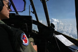
Powerful. Ferocious. Intense.
These words are commonly used to describe a major hurricane bound to make landfall on U.S. soil. The amount of catastrophic destruction these monstrous storms can cause makes it an important mission to keep the American people informed, prepared, and involved.
To embark on and succeed in this specialized mission, agencies such as the National Oceanic and Atmospheric Administration, the National Hurricane Center, and the National Weather Service utilize the U.S. Air Force Reserve’s 53rd Weather Reconnaissance Squadron to fly through the storms to take detailed observations and gather important data to send back to the agencies. The partnerships ultimately help improve the forecasts of tropical cyclones threatening the U.S. coast. While most aviators do their best to steer clear of storms, these crew members actually hunt them. Alongside their NOAA counterparts, these individuals are commonly known as the Hurricane Hunters.
“The mission of the Hurricane Hunters really impacts the American people by giving us better weather data, which improves the accuracy of forecasts,” said 1st Lt. Rileigh Sevigny, 53rd WRS navigator. “It actually can improve the infamous cone (of uncertainty) that you see by about 30%.”
The information gathered in flight, including wind speed, wind direction, temperature, pressure, and humidity, is distributed directly to the NHC, triggering a ripple effect among various agencies and media outlets as a result of improved forecasts.
“It gives the people who are making decisions for evacuation versus non-evacuation a bigger lead time and more of a heads-up of where the hurricane is actually going to make landfall and how it will affect the everyday lives of American people,” said Sevigny.
Aboard the WC-130J, a military aircraft that includes specialized weather instrumentation, the basic crew consists of the aircraft commander, a co-pilot, a navigator, an aerial reconnaissance weather officer, and a loadmaster. Each plays a crucial role in supporting the hurricane mission. Pursuing the chaotic storms, which are formed by powerful heat engines and driven by the strict laws of physics, warm ocean water, and Earth's rotation, the crew thereby strengthens readiness back on the home front.
“As pilots, we have to ensure that we have all the proper clearances to get into the airspace, and that we're clear of terrain, clear of traffic, and that we're operationally legal to be where we're at,” said Capt. Ashley Kosturock, 53rd WRS pilot.
Planning and executing the mission are everyone’s responsibility, but the pilots' sharp skills are crucial to the crew's safety.
“Sometimes turbulence can be so severe that the autopilot disconnects, and one pilot may have to hand-fly the airplane while the other manages the throttles,” Kosturock said. “At that point, the two pilots must work together to make sure they don’t overspeed or stall the airplane. Most hurricane training is on the job because you can’t truly replicate those conditions, even in a simulator.”
Helping pilots maneuver their way through the storm are the navigators. They are also seated in the flight deck directly behind the pilots.
“As navigators in the storm environment, we're kind of the go-between for the back of the plane and the pilots,” said Sevigny. “The aerial reconnaissance weather officer is telling us where they want to go in the eye of the storm to collect the data they need, and we are checking our radar, making sure it's a safe direction, and passing on a heading to the pilots.”
Just like the green imagery radars seen in movies, navigators use low-powered weather radars to help find a safe direction in flight.
“There will be little things that kind of pop out on the edges of the storm that create a lot of turbulence and could cause us to lose altitude quickly,” said Sevigny. “We want to avoid those to the best of our ability. So, if we see something like that on the radar, we will choose maybe a slightly different heading than what's directed by the ARWO in the back.”
The ARWO and loadmaster sit in the cargo area of the aircraft on specialized pallets, where they collect critical weather data throughout the mission.
“While we're on board the aircraft, first we're working with the crew to ensure that we fly where we need to go to collect the data,” said Maj. Garrett Black, 53rd WRS ARWO. “And then, with the help of our loadmasters, we release and utilize specialized weather instruments to ultimately collect and compile data onto our computers. From there, we can assess the data quality and then send it directly to the NHC.”
As the aircraft traces its alpha pattern through the storm, loadmasters complement the ARWO by deploying the physical sensors at strategic points within the eyewall and eye to capture that critical data.
“We drop sensors, called dropsondes, from the aircraft to the surface that measure wind speed, wind direction, temperature, dew point, and pressure,” said Tech. Sgt. Vincent Boyd, 53rd WRS loadmaster and dropsonde operator. “It'll fall at about 2,500 feet per minute, and as it drops to the [water’s] surface, it's picking up the data, and once it hits the water, it terminates.”
The purpose of this task is to fix the storm so we can track exactly where it’s going, explained Boyd. “We look for an area where the winds drop to almost zero, then fly our alpha pattern around the storm and return to that same spot,” he said. “That essentially tells us how far and in what direction the storm has moved.”
For the people back at home watching the forecast and the hurricane cone, the mission helps narrow the storm’s projected path, allowing for better-informed decisions and a more effective response.
“By going out and collecting this atmospheric data over very sparse regions of the oceans, we can really hone in on those weather models and enhance the weather forecasts to allow people to have more advanced warnings,” said Black.
Across the 53rd, some Hunters are passionate about the overall mission simply because of a personal connection to severe weather.
“I grew up in Kansas, so tornadoes really got me into weather,” said Black. “As I continued to go through my meteorology program in college, I heard about this unit way back then. I thought this was a very exciting way to help people, but also to actually be out exploring the weather, and feeling its impacts, while helping others be more prepared for those impacts.”
For others, a single direct hurricane in their own lives was all it took to be drawn to the mission.
“Growing up in South Mississippi, I was directly affected by Hurricane Katrina in 2005,” said Kosturock. “I remember seeing the effects of the powerful water that swept away the homes, leaving nothing but concrete and oak trees.”
The mission is personal for many in the squadron. Seeing the impact of hurricanes on communities motivates them to continue their efforts.
“It has had a lasting, resounding impact on my family and on the coastline as well. I have personal photos that inspire me to keep doing what I do,” said Kosturock. “I usually keep them in my helmet bag.”
While the hurricane intensifies at sea, these Air Force reservists don’t just await its arrival, they set out to face it head-on. Much like a battle against the forces of nature, they use their skills and specialized weather instruments to keep the lives of the American people in its path as safe as possible.
“You're helping people save lives and stay out of harm's way,” said Boyd. “And that’s worth it.”
Powerful, ferocious, and intense may describe the hurricane, but…
Resilient. Determined. Dedicated.
These are words that can define the Hunters- the Hurricane Hunters.