For more than a century, the U.S. Army Corps of Engineers (USACE) has designed, constructed, and maintained the nation’s inland navigation infrastructure. From the early hand-drawn plans used to build locks and dams along the Allegheny, Monongahela and Ohio rivers to today’s sophisticated computerized technology, engineering tools have evolved dramatically, improving accuracy, collaboration, and efficiency across the career field.
“In the early days, they used these hand drawings, and there would only be one,” said Chris Miller, Computer- Aided Design (CAD) and Building Information Modeling (BIM) regional technical specialist with the Great Lakes and Ohio River Division. “They would take this one drawing to the construction site with them, and they still managed to build things. That’s amazing to me; they were so skilled.”
At the U.S. Army Corps of Engineers Pittsburgh District, BIM and CAD evolution, added to engineering technology reflect decades of innovation supporting a crucial 981-mile inland waterway system, stretching from the Point of Pittsburgh to Cairo, Illinois and the Ohio River Basin.
Early lock-and-dam projects relied entirely on manual drafting techniques. Engineers and surveyors created detailed drawings by hand using pencils, ink, scales, and drafting tables. Many of the Pittsburgh District’s original inland navigation structures, including the recently removed Elizabeth Locks and Dam (completed in 1907) and original lock chambers at Braddock, completed in 1906, along the lower Monongahela River system, were painstakingly constructed by hand-drawn plans.
For decades, those drawings served as the foundation for design, construction, and maintenance activities. Engineers carefully updated blueprints by hand, often storing large paper archives that documented generations of infrastructure improvements. Even today, many historical as-built drawings remain valuable references for modern rehabilitation projects.
“We operate facilities which are old (over 50 years) and have had a lot of work done on them,” said Col. Nicholas Melin, commander for the USACE Pittsburgh District.“This means there are binders of design documents that engineers need to work their way through to understand the current state of the facility before they can design and execute a repair.”
The transition from paper drafting to Computer-Aided Design and Drafting (CADD) began accelerating across the engineering industry during the 1980s and 1990s. CADD-enabled engineers were able to create digital drawings faster and with greater accuracy, significance, and reduce repetitive manual work.
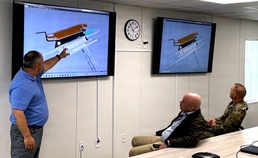
“Through the use of BIM, we have been able to provide more detailed and accurate designs earlier that ultimately lead to better quality drawings and 3-D models for construction and fabricators,” said Miller.
In inland navigation projects, the adoption of CADD transformed the way engineers developed lock chambers, dam gates, mechanical systems, and structural layouts. Digital drafting improved consistency between disciplines and made it easier to revise designs throughout a project’s lifecycle. Instead of redrawing entire sheets, engineers could quickly modify digital files, saving both time and resources.
As computing power expanded, three-dimensional modeling capabilities advanced as well. The engineering industry gradually moved beyond simple drafting into integrated digital modeling environments known as Building Information Modeling, or BIM.
“BIM is the private industry standard, so the Corps is in the process of really catching up with the current state-of-the-art,” said Col. Nicholas Melin.
Unlike traditional CADD drawings, BIM creates intelligent 3D models containing detailed engineering, structural, and operational data. Designers can coordinate multiple disciplines within a single model, helping identify conflicts before construction begins. For complex civil works infrastructure such as locks and dams, BIM provides significant advantages in visualization, construction sequencing, and long-term asset management – enter digital twins. The engineering world’s version of cloning.
“Using BIM modeling has allowed designers to fully integrate the design of individual components and features into a three-dimensional model,” said Col. Nicholas Melin. “Developing digital twins of each facility will allow the Corps to have accurate as-built modeling of each facility that can be used by our Operations personnel as they conduct repairs and our engineering and construction teams as we do larger construction jobs.”
Modern inland navigation projects frequently combine multiple digital tools, including Autodesk Revit, Civil 3D, Inventor, Navisworks, and other structural analysis software, to develop highly detailed infrastructure models. Engineering professionals across the Corps increasingly rely on BIM workflows to improve collaboration among structural, mechanical, electrical, and geotechnical teams.
“BIM is also allowing us to collaborate better with our construction industry partners,” said Col. Melin. “We share the BIM model for new facilities as we conduct the solicitation process, which allows companies to have a clear understanding of what is required and develop better, lower bids.”
The Corps continues modernizing navigation infrastructure nationwide. Recent initiatives focused on resilient lock and dam operations (formerly known as remote locking) emphasize standardized digital systems and modernized control technologies that will support future navigation reliability and operational efficiency. Current lock modernization efforts include transitioning from older analog systems toward integrated digital controls and enhanced monitoring capabilities.
For the Pittsburgh District, digital engineering tools now play a critical role in major infrastructure investments across the region. From navigation chambers and flood control projects to dam rehabilitation and maintenance planning, CADD and BIM technologies help engineers evaluate designs, improve coordination, and reduce construction risks before work begins in the field.
“BIM enables more accurate and efficient design work because designers can see how their work fits into the digital reproduction of the facility. So much of engineering design is based on site characteristics,” said Col. Melin. “Being able to see how one’s design ‘fits’ into the facility prevents costly mistakes that really only show up once the facility is being constructed.”
Although technology has changed dramatically, the mission remains the same: delivering safe, reliable infrastructure that supports navigation, commerce, and public safety.
Today’s digital models may look far different from the hand-drafted plans created generations ago, but both represent the same commitment to engineering excellence that has defined the Corps of Engineers for more than 250 years. Through the Assistant Secretary of the Army for Civil Works, the Honorable Adam Telle’s Build Infrastructure Not Paperwork (BINP) initiative, USACE is making a greater commitment to civil works efficiency.
“BINP, at its core, seeks efficient delivery of infrastructure to support the American economy and people,” said Col. Melin. “Having technology that shortens outages of USACE infrastructure because the team can figure out what’s wrong and how to fix it also fits. Having detailed 3D models that can be shared with our contracting partners and yield more accurate and lower bids on upcoming work saves the American taxpayer money and enables us to deliver more for each dollar provided to the Corps.”
“One could imagine a future where the designer asks an AI bot questions about the facility, which are answered through the BIM model, and support more rapid and cost-effective design execution,” said Col. Melin.