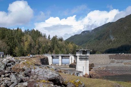
Five feet of floodwater is enough to swallow a car, overtake the first floor of many homes, and close major arterial roads and highways. Before Howard A. Hanson Dam was completed in 1962, flooding along the Green River was a regular part of life for many Washington communities in King County, with major floods repeatedly inundating farms, businesses, and small, but growing towns throughout the Green River valley during the late 1800s through the mid-1900s.
For more than 50 years after the dam’s completion in 1961, that history helps explain why flood risk management remains one of the U.S. Army Corps of Engineers' (USACE) most important missions.
During one of western Washington's most significant flood events in recent history in December 2025, USACE Seattle District flood risk management dams, water managers and emergency response operations helped reduce flood risk across the Puget Sound region by holding back peak flows, protecting communities, and helping prevent an estimated $8.7 billion in potential flood damages.
“No single project can eliminate flood risk during weather events of this magnitude, but by working together and carefully managing reservoir operations, we were able to significantly reduce downstream flooding and help protect the communities we serve," said Kyle Comanor, USACE Seattle District senior water manager.
A summer 2026 preliminary analysis indicate operations at Howard A. Hanson Dam helped prevent an estimated $7.8 billion in downstream damages along the Green River, while operations at Mud Mountain Dam helped prevent an estimated $215 million in damages along the lower White and lower Puyallup rivers.
The data used to calculate the prevented damages included everything from weather and riverbed terrain to the national inventory of structures – each with an estimated value to determine what a floods economic impact would have been.
"To calculate damages prevented, we model reservoir operations, and we model what would happen if the water flowing into our reservoirs was instead passed right on through down the river," said Brendan Comport, a hydraulic engineer with the Seattle District. "That's a totally hypothetical scenario, which is why it's so important we have accurate predictive models.”
Throughout the December 2025 event, Seattle District water managers operated its Howard A. Hanson and Mud Mountain dams. The district also regulated Ross Dam (Seattle City Light), Upper Baker Dam (Puget Sound Energy), and Wynoochee Dam (Tacoma Public Utilities) under established agreements allowing USACE to regulate waterflow for city and utility-owned dams during flood events, referred to as Section 7 reservoirs.
Seattle District dams and Section 7 reservoirs helped reduce flood risk by temporarily storing floodwaters and releasing them in a controlled manner after river conditions improved.
Throughout the flood event, USACE water managers worked closely with utilities like Seattle City Light to openly share information regarding evolving forecasts, anticipated reservoir operations, and changing conditions across the Skagit River basin. That coordination helped both organizations maintain a common operating picture during the prolonged storm.
"Seattle City Light appreciated the strong communication and coordination with the U.S. Army Corps of Engineers leading up to and during the historic flood events on the Skagit River in December 2025,” said Robert Santoff, Seattle City Light interim general manager and CEO. “Their transparent and collaborative approach enhanced situational awareness and supported timely, informed decision-making throughout the event."
Ultimately, coordinated flood-management operations with utility-owned reservoirs on the Skagit and Wynoochee rivers helped reduce an additional $746 million in potential damages.
"Our mission is to reduce flood risk for the communities we serve," said Comanor. “During this event, careful reservoir operations and close coordination with our partners helped reduce downstream flooding to lives, property, and critical infrastructure."
Unlike typical Washington winter storms, the December event consisted of six atmospheric river pulses over nearly two weeks. Each successive atmospheric river arrived before rivers and reservoirs could fully recover from the previous one, requiring continuous reservoir management and around-the-clock coordination among federal, state, county, utility, and local emergency management partners.
Before the first atmospheric river arrived, the Seattle District Emergency Operations Center and Reservoir Control Center began monitoring forecasts, river conditions, and available reservoir storage. As conditions worsened, the district transitioned to continuous 24-hour operations to manage reservoir storage, monitor river conditions, and help share flood response updates with government partners across western Washington.
While no flood risk management project can eliminate flooding during extreme weather events, temporarily storing floodwaters behind dams reduced downstream river levels and help lessen impacts to homes, businesses, farms, transportation corridors, and other critical infrastructure.
USACE Dams, By the Numbers
An empty reservoir, or “pool” is the best situation USACE water managers want prior to any potential flooding. This scenario allows the reservoir to fill quickly and “hold back” the newly captured storm water; water managers then slowly release that water after the storms have passed and natural river flows have lowered enough to absorb more water released from the dam. In this “rinse and repeat” cycle, water is released after a peak reservoir elevation is reached and quickly refills during heavy and sustained rain.
During big rainstorms, USACE water managers carefully release water to prevent much worse, uncontrolled flood releases later.
Data showed that Howard A. Hanson Dam reduced peak flows on the Green River by approximately 58% and lowered peak river stages by more than five feet, reducing the likelihood of catastrophic flooding in Auburn, Kent, Tukwila and other nearby communities.
Forecasts showed both reservoirs could reach critically high levels. Water managers carefully adjusted releases throughout the storm to maintain flood storage for incoming runoff while avoiding uncontrolled spillway releases and protecting downstream communities.
Although the storm proved historic, reservoir conditions remained below the most extreme forecast scenarios. Even so, Howard A. Hanson Dam reached a record pool elevation of 1,189.3 feet and stored 77,700 acre-feet of water, filling about 75% of its available flood storage capacity. Never in the project’s history had it stored as much water in its reservoir. Seattle District water managers had a record amount of water to get rid of.
During these kind of storms, USACE water managers carefully balance the need to store incoming floodwaters with the need to safely release water downstream. These controlled releases help protect communities by reducing the likelihood of more dangerous, uncontrolled spillway releases while maintaining the dam's ability to capture additional floodwater.
"Reducing risk to the public by emptying reservoir pools as quickly and safely as possible was critical," said Travis Ball, Seattle District chief of hydraulic and coastal engineering. "As inflows increased with each incoming storm, our teams continually balanced reservoir storage with downstream river conditions to manage releases as safely as possible."
Along the lower Puyallup River, Mud Mountain Dam held back severe floodwaters during the weather event, slowing the amount of water moving downstream and protecting an estimated 400,000 people in the lower Puyallup River valley. That helped keep the river nearly two feet lower through the City of Puyallup at the height of the flooding, reducing flood risk for nearby homes, businesses, roads, and other infrastructure.
As river levels continued to rise, Mud Mountain Dam acted like a giant temporary storage basin. Instead of allowing floodwaters to surge downstream all at once, the reservoir safely held back enough water to fill about 70% of its available flood storage space before gradually releasing it, and only after the greatest flood risk had passed.
A Regional Flood Fighting Effort
In addition to dam operations, Seattle District supported communities through its emergency management mission by providing engineering and flood fighting expertise, emergency contracting support, flood-fighting supplies, and liaison officers to emergency operations centers throughout the region. These efforts complemented reservoir operations and helped state and local partners respond to rapidly changing conditions during the prolonged extreme weather event.
USACE also maintained regular communication with impacted counties and downstream communities, providing technical information, operational updates, and resources to help local agencies respond to changing conditions. That coordination gave local emergency managers and public works departments the information they needed to make timely decisions as river levels changed.
One such partner was Pierce County, home to the Puyallup River watershed, which drains 1,040 square miles of water downstream to the Lower Puyallup River Floodplain.
“USACE shared clear, timely updates at daily briefings during the [December 2025] flood event that helped our public works teams and emergency managers plan and direct resources where they were needed most,” said Helmut Schmidt, Pierce County floodplain administrator. “This open communication supported local planning and strengthened the partnership. They helped make the region’s flood response a real team effort.”
Beyond the technology, infrastructure, and partners, the Seattle District’s flood fighting efforts depended heavily on the personnel managing the crisis. Technology provides data, but experienced water managers, emergency response personnel, and county and city partners apply professional judgment when interpreting incoming data during a rapidly changing flood event.
"Having experienced personnel is super important in managing reservoir operations," Comport said. "Our staff have done this long enough to know how to spot problems before they actually become problems—like a streamgage that needs verification because what we’re observing doesn’t match instrument reading. That's how we head off issues, and it's why it's so important to have the right team."
For USACE water managers, December 2025’s atmospheric rivers demanded continuous monitoring, rapid decision-making, and tight coordination with partners across western Washington, such as United States Geological Survey (USGS).
USGS crews conducted daily field visits to keep streamgages operating, measure rapidly changing river flows, and verify the continuous data available to the public.
“Effective flood response depends on reliable, timely information,” said Chris Laveau, USGS Water Science Assistant Director for hydrologic date. “Our work supported forecasters, reservoir operators, emergency managers, and communities with current information from 27 gages in the Puyallup River watershed and 16 in the Green-Duwamish River watershed.”
Flood Risk Management, A Shared System
Flood risk management relies on multiple components working together. While reservoirs temporarily store floodwaters to reduce the amount of water flowing downstream during major storms, levees help keep rivers within their channels.
A busy, non-stop summer levee construction season will first begin with levee repairs on the Cedar River, located in Washington’s King County. Under Public Law 84-99, USACE is authorized to assist in the rehabilitation of flood-damaged levees when requested by local governments. USACE Seattle District is poised to rehabilitate a total of 16 levees damaged in the December 2025 flood event ahead of the 2026-2027 flood season throughout Washington State, with 14 in Western Washington.
“Thanks to the extremely strong partnership between the Army Corps of Engineers, the state, and our local partners, we have been able to drastically accelerate the design and repair timeline to deliver critical repairs and reduce flood risk to our local communities,” said Lt. Col. Brandon Nall, Seattle District levee rehab task force lead.
While no single flood risk management measure can eliminate flooding during extreme weather events, together these measures help reduce impacts to communities across the Pacific Northwest.