Precision in the air: district expands drone operations
By Sheandra Sterling, New England District
CONCORD, Mass. -- Whether it’s for environmental surveys, construction monitoring, or disaster response, the unmanned aerial system program is rapidly becoming a force multiplier for the New England District mission. The survey team at former the Fort Devens recently completed specialized drone training where the focus was to sharpen pilot skills and integrate the latest sensor technology into field operations.
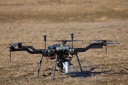
The Harris Aerial Carrier H6 Hybrid Drone is built to support professional-grade payloads, up to 11-pounds, and includes LiDAR, photogrammetry sensors and large inspection equipment. This allows exceptional versatility in power options for multi-hour flight time.
The training highlighted how far aerial capabilities have advanced beyond simply taking photographs. The technology is called Light Detection and Ranging, or LiDAR, which allows operators to penetrate dense canopy cover and capture high fidelity terrain data with incredible precision.
“It was very helpful to have the vendor on-site to walk us through the new sUAS’s particulars… every drone is a little different” said Jon Belmont, Chief of Staff, USACE NAE. “This one is much larger than our others, uses a unique, hybrid powerplant, and has a different control scheme. Personally, I preferred it – its control logic is more intuitive for me as a former crewed rotary-wing pilot – but I acknowledge that it would be “overkill” for most of the non-surveying, photo/video footage missions I’ll be more likely to support, so I need to keep brushing up on my skills with the smaller airframes!”