FORT LEONARD WOOD, Mo — Geospatial engineers from around the world are navigating to Fort Leonard Wood, the home of the U.S. Army Engineer Regiment, to compete in the Regimental Best Mapper Competition March 27-30, 2026.
According to Chief Warrant Officer 5 Jason Davis, senior geospatial integrator with the [Geospatial Enterprise Office](https://home.army.mil/wood/units-tenants/GEO), the 19 teams of two, will be judged on their ability to perform time-constrained physical and mental challenges that test geospatial and communication skills, along with Soldier tasks, such as land navigation.
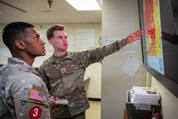
Davis said Soldiers trained in the 12Y military occupational specialty are part of a “very technical MOS” responsible for generating, managing, analyzing and disseminating geospatial data and products.
This is the third year the Best Mapper has been held at Fort Leonard Wood, which is also the only place U.S. Army [12Y Geospatial Engineers](https://www.goarmy.com/careers-and-jobs/mechanics-engineering/design-develop/12y-geospatial-engineer) can learn their trade during advanced individual training with the 169th Engineer Battalion, 1st Engineer Brigade.
During the competition, geospatial experts will be demonstrating their ability to analyze the land and battlefield of unfamiliar terrain..
“Commanders and their staff heavily rely on their expertise and capabilities for situational awareness of terrain and advice on how terrain can be used to gain tactical advantage or protection,” Davis added.
According to 1st Lt. Hunter Wall, geospatial development officer, of the 19 teams competing, four are international partners, including Germany, Denmark and two teams from the United Kingdom.
“This will be the third year of this competition, and it is better than ever. Much like the rapid transformation that we have seen across the engineer regiment and the Army, this competition aims to demonstrate the unique and necessary capabilities that geospatial engineers can provide to commanders across all Army and joint commands, at all echelons,” Wall said.
The competition will include 10 technical and tactical events, and four physical components.
“The majority of the competition is a technical demonstration of how geospatial engineers support all warfighting functions. They will create decision aids that enable commanders and staff to plan and execute command and control and maneuver, as well as producing geospatial products that support layered protection, fires, sustainment and intelligence operations,” Wall said. “We are excited with the physical competition events the 169th Engineer Battalion has prepared for the competitors as well.”
Davis said geospatial engineers currently learning their trade at Fort Leonard Wood will have opportunities to watch the competition.
“12Ys in a training status will get to see firsthand how the skills they are learning now play a vital role in not only the competition, but as a geospatial engineer when they eventually go out to the force,” Davis said.
Spectators will have several opportunities to watch and cheer on competitors.
Starting at 1:30 p.m., March 27, spectators can watch the first of four physical events at Gerlach Field where competitors will conduct a non-standard fitness test.
“On March 28, they will also conduct the x-mile run at Carwash Hill in the morning, followed by the physical endurance course, starting at 1:30 that same afternoon.” Wall said.
The physical endurance course is located at Fort Leonard Wood Training Area 97.
This year’s culminating event, Mapper Trials, is also spectator friendly. It is slated to be held at 2 p.m., March 29 on Gammon Field.
“We highly encourage everyone to come watch and support their fellow engineers during these events,” Wall said.
For any additional questions, community members with post access who wish to follow the competition may find event times and locations at the Best Mapper help desk located in the atrium of Brown Hall, Bldg. 5400.
“There they will be able to see the entire competition timeline, current team placement, event locations and start times,” Wall added.
The winning team is scheduled to be announced at 9 a.m., March 30 in the Engineer Regimental Room at the John B. Mahaffey Museum complex.