In a utilitarian structure of reinforced concrete, a bastion of pragmatism near the Trinity River, there worked a group of government employees, cartographers not of lands, but of interventions. They are assets of the United States Army Corps of Engineers, Fort Worth District, and their charge is a solemn one: to translate USACE’s immense, earth-altering projects from the sterile domain of engineering schematics and hydrological models into the authoritative and comprehensible form of the map. Theirs is not an art of mere illustrations, but of sober visualization, a critical bridge between the raw power of engineering and the human landscapes it was designed to protect or create.
A melding of the old and the new
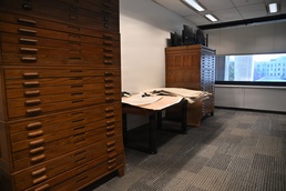
The tools of Lisa Fergeson’s trade are a study in stark contrast between old and new. Her workspace is surrounded by filing cabinets heavy with impact reports, regulatory compliance documents, and old paper maps. On her computer, complex Geographic Information System or GIS software hums, layering subterranean utility corridors, soil compaction data, and projected flood plains. USACE and its partners demand digital precision while its history is written on linen maps. They believe in a decision today that could divert a river, raise a levee or emplace a new barracks on an installation that requires precision; and being able to interpret the past will make the difference. It’s not just pixels; it’s the way ahead. Weaving traditional craft with digital precision can sometimes clear up questions.
“Sometimes it’s the case where someone may be encroaching on to government property or we’re doing an acquisition of a tract of property,” said Fergeson, a cartographer in the Fort Worth District Real Estate Division. “We’ll end up having to get a survey completed. Then we'll use that data to compare and determine the status using older contour data to see what, if any changes exist.”
Mapping future flood risk mitigation
Justin Weeks is another cartographer with the Fort Worth District. His current projects include the Dallas Floodway and Dallas Floodway Extension as well as the Central City Project, a project of immense scale and profound consequence. On his screen, it is a violent clash of data: crimson algorithms representing storm surge battling against the topographical blues of the river basin, all overlaid with the stark black grids of urban infrastructure. The proposed levees are not gentle slopes but assertive, confident berms, their cross-hatching indicating layers of geotextile fabric and compacted earth. The new floodgates are rendered not as ideas but as immense, mechanical structures, their heaviness implied by the density of the lines. He charts the future flood zones not with artistic suggestion, but with strict, color-coded halftones—a legal and practical warning etched into the future.
“Our drive is to help communities and try to prevent disasters,” said Weeks. “Helping the design team to deliver the projects that improve the nation brings a lot of pride and a little bit of personal accomplishment.”
This is the essence of his solemn duty: the marriage of immense force to absolute clarity. Where an engineer sees stress coefficients and hydrological calculus, Weeks sees the neighborhoods, and interstate highways that calculus was designed to save. His map is the first and last word for bulldozer operators, project managers, and public officials. A misplaced line could misdirect millions of gallons of water; a perfectly placed one could secure a city’s future. He often visits the sites, not to be seen, but to feel the soil under his boots, to gauge the flow of the current, and to stand silently in the neighborhoods that existed only on the “before” side of his maps. He is mapping time, but it is time measured in seasons, in storm events, in the slow creep of erosion—and in the urgent minutes of a flash flood.
It all starts and ends with mapping
“Before the Corps of Engineers acquires or disposes a tract of land it is mapped,” said Daniel Mowdy, a Fort Worth District cartographer. “We map out the area and send it to a surveyor to verify before appraisers make an evaluation of the tracts worth.”
The weight of this responsibility is his constant and grim companion. His maps are legal documents, tools for eminent domain, guides for colossal budgets, and ultimately, promises of safety. There is no room for the romantic suggestion of dappled light; only the unequivocal statement of elevation and gradient. The completion of a map is not a genesis of beauty, but the finalization of a strategic plan. When he presents his drawings, officers and project managers will lean in, their fingers tracing the bold lines of the new barriers, their faces etched with the understanding of the power and cost they represent. His maps are not provocations to dream, but blueprints for action; they make the abstract, terrifying power of water into something that could be managed, contained, and defeated.
“Mapping is taking the written word that we place into software, such as ArcGIS Pro, and displays it,” said Minnie Barker, a cartographer who first mapped with the Omaha District in 1983. “Those words could be a description of a tract of land or a survey report.”
In an era of climate uncertainty and increasingly volatile nature, cartographers serve as a vital interpreter of control. The Army Corps of Engineers commands the muscle to bend geography to its will, and cartographers provide the vision for that herculean effort. In their austere office, amid the hum of computers and the scent of ink, they draft not just channels and berms, but stability itself. They are the cartographers of consequence, ensuring that the future is approached not with hopeful ambition, but with calculated, irrevocable, and life-saving intention. Their legacy will be silent and unseen—found in the dry yards of a thousand homes, the un-flooded streets of a storm-prone city, a landscape ordered against chaos, a testament to the power of human foresight made manifest on a map.