By Jodi Moffett, Cadet Command Public Affairs
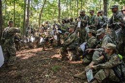
FORT KNOX, KY.— Cadets from 3rd Regiment, Basic Camp laced up their boots and grabbed a compass for their land association and map reading courses on July 13.
Broken off into their platoons, Cadets rotated through a circuit of four stations and were taught the basic skills needed to pass land navigation.
The first of these stations was map reading, where Cadets are taught how to plot points, shoot an azimuth and determine distance when navigating their terrain.
“The maps themselves are one of the most important aspects of land navigation,” Cadet Michael Silva, a student at the University of Wyoming said. “Being able to read and locate different points in elevation, and using them to locate where a water source may be is something every Cadet has to know how to do.”
Next, Cadets learn how to use a key tool for land navigation- their compass. Learning to use their compass also includes how to hold their weapons while out in the woods, keeping in mind that the metal on their weapons affects the accuracy of their azimuth.
Once Cadets are taught how to use their compass, they move on to establishing their pace counts. Cadets navigate through different terrain, counting their paces as they go. They then use this information to calculate their average pace count.
Cadet Eseosa Omobude, a student from Georgia State University, values pace count the most when tackling land navigation.
“Pace count, in my opinion, is the most important part of land navigation,” Omobude said. “Reading a map is great, but you have to always know the distance you have traveled… and that’s exactly what pace count allows you to do.”
After determining their pace count, Cadets move on to review major terrain features, and they use a very interesting mnemonic to do so.
Hidden Valley Ranch Salad Dressing is how Cadets remember the 5 major terrain features that they can encounter during their land navigation. Those terrain features include hills, valleys, ridges, saddles and depressions.
“Hidden Valley Ranch Salad Dressing is an easy way for Cadets to memorize the terrain features,” Staff Sgt. William Benson said. “How could you forget it? That stuff is delicious.”
After a morning of reviewing basic land navigation, and cravings for Hidden Valley Ranch, Cadets choose a battle buddy who they will locate three of four points with later that afternoon. Cadet Jalen Weaver, a student from the Marion Military Institute, knows that having a reliable battle buddy is key when learning how to succeed at land navigation.
“I’m coming pretty much straight from high school, so I’m new to land navigation,” Weaver said. “I paired myself with an experienced battle buddy, so we can benefit from working together in the field. I can help with things he doesn’t know, and he can help me when I don’t know something.”
Regardless of their skill level, all Cadets were reminded of what is most important during land navigation- staying calm.
“You have to keep a clear mindset when you’re out in the woods,” Cadet Taylor Hamilton, a Cadet from Slippery Rock University said. “If you get lost, you have to keep calm, think and remember everything you’ve been taught.”
“Keeping a steady pace can only take you so far… you have to also keep a steady mind.”