The rising waters of the Washita River crept over the crest of the Cumberland Levee in the late morning of June 20, 2015.
That initial flow of high water quickly overtopped an entire stretch of the levee, and entire portions of the structure broke away. Historic flooding spring and summer flooding in 2015 resulted in the fracture of previously held rainfall levels in Oklahoma.
Within 24 hours the initial breach, an 800 foot stretch of the structure was washed away. For the first time in more than 60 years the Washita River returned to the “Old Washita River Basin”.
The flooding that resulted covered several thousand acres of trees, dozens of oil wells, State Highway 199 and utility and electrical transmission lines.
Located about 16 miles northwest of Durant, Oklahoma, the Cumberland Levee forms the northwestern edge of Denison Dam.
Constructed in 1943 as part of the Denison Dam project, the structure was built specifically to protect the Cumberland Oil Fields, which were considered a strategic, wartime, national resource.
By design, local runoff and seepage within areas protected by the levee system do not gravity drain and are routinely pumped into Lake Texoma. To prevent flooding of the oil fields located below the levee, various oil and gas companies operate and maintain a drainage pump station located at the south levee to keep their areas of operation free of runoff water. This work is generally done at no expense to the U.S. Government.
Of Dearth and Abundance
As late as mid-May the region was struggling through the fifth year of an unwelcome drought.
From 2010 to 2015 the 39,719 square mile Upper Red River Basin which stretches from eastern New Mexico across the lower portion of the Texas Panhandle, into Oklahoma, and down to the Oklahoma-Texas border, saw minimal rainfall. Low-water conditions had a significant impact on the regional economy and damaged recreation opportunities. Communities on both sides of the border, which Lake Texoma straddles, felt the pain as lake levels remained well-below normal.
Despite increased precipitation during the first four months of 2015, U.S. Drought Monitor maps continued to show tan to dark-red splotches, the color code depicts “abnormally dry” to “exceptional drought” conditions.
As late as May 12, the region remained in near drought, but the next 19 days would mark the end of dry conditions. May would become the wettest month in recorded history for both Texas and Oklahoma. The Lone Star State recorded 8.81inches while the Sooner State recorded 14.40 inches of rain.
Vast portions of the Upper Red River Basin received significant rainfall through May and June. Reservoirs filled and a water famine transformed into liquid abundance.
From Denison Dam east to the Arkansas border, the 3,400 square mile Lower Red River Basin marks the final leg of the Red River’s 200-mile, meandering trek from the dam to Arkansas’ border with Oklahoma.
Of the five Corps-managed reservoirs in the Lower Red River Basin, three – Pat Mayse, Hugo and Sardis – feed into the Red River.
As inland rains continued to fall, tropical Storm Bill made landfall in Texas on June 16 and reached Oklahoma shortly thereafter. The massive storm drenched the region. By June 17 all watersheds in the district’s Red River Area were above 99 percent of their flood control pool, all were receiving inflows and all were forced to release water due to slowly rising lake levels.
This combination of rainfall in the Upper and Lower Red River watersheds presented a difficult situation for water managers in the U.S. Army Corps of Engineers, Tulsa District’s Water Management Section. As runoff from rainfall into the Red River below Lake Texoma captured valuable channel capacity, water managers attempted offset upstream inflows.
“The challenge was sharing downstream channel capacity with Hugo Lake and downstream runoff into the Red River,” said Tammy Piazza, who managed water releases at Lake Texoma during the 2015 flood. “There was a lot of rainfall below Lake Texoma in an uncontrolled area, and that affected our ability to release.”
The Cumberland Levee
Constructed in conjunction with Lake Texoma, between 1939 and 1945, the Cumberland Levee rises to an elevation of 647.0 feet above mean sea level and forms what is commonly referred to by locals as the “North Dike” of Denison Dam.
Prior to construction of Denison Dam, discovery of oil in the Cumberland Gap resulted in the propagation of oil wells. By the time appropriations for the construction of Denison Dam came through, the nation was in the midst of World War II. Secretary of War, Henry L. Stimson, approved the construction of the Cumberland Levee, declaring the Cumberland Oil Field a strategic asset of national importance.
In response to Secretary Stimson’s order, the Denison District, which merged with the Tulsa District in 1945, constructed the 23,480-foot long levee, thus redirecting the flow of the river to allow for oil field production access. When the Washita River overtopped the Cumberland Levee in May, 2015, it marked the first time in more than 70 years its waters would inundate the original Washita River Basin.
The Breach
During the last week two weeks of May, Tulsa District officials determined that significant flooding was expected and dispatched engineers to monitor the structure. In accordance with standard operating procedures, the Lake Texoma Project Office dispatched park rangers to inspect the structure and collect piezometer readings during 24-hour flood fight operations.
Engineers effectively used heavy machinery to create windrows by returning settled sections of the levee to elevation 647. This action successfully prevented an overtopping of the structure on May 28.
Twenty three days later, with Lake Texoma more than five feet above the top of the flood control pool and inflows exceeding 250,000 cubic feet per second, the levee overtopped. Twenty-four hours later, the structure breached.
As no homes or dwellings were below the Cumberland Levee no loss of life occurred from the breach but the impacts to infrastructure were significant. Floodwaters inundated approximately 2,000 acres of property, and an estimated $40 million in infrastructure, including Oklahoma State Highway 199, a major arterial thoroughfare. Two major power transmission lines were also submerged, requiring power companies to reroute electric service to reach end users in nearby communities.
As a result of the breach, underground utilities and two petroleum pipelines were also inundated by the Washita River. In some areas, flood waters in inundated areas were more than 70 feet deep.
Once it was safe to enter impacted areas below the breach, Tulsa District project personnel and dam safety engineers rushed to the site to survey the effects and develop a plan to mitigate additional damage and allow dewatering efforts to take place so that work could begin to repair the levee. Removing the water, would take months. Approximately 117,000 acre feet of water filled the area, roughly the equivalent of covering the island of Manhattan in eight feet of water.
To expedite dewatering efforts, the project development team determined that a two-stage approach would be the best means of returning the structure to pre-event status.
Once flood waters receded, the first phase of the project required construction of a temporary cofferdam. The cofferdam would segregate water in the lower, flooded area from Lake Texoma to allow removal of floodwater, and provide a degree of protection from flooding during future high-water events while the main structure was repaired.
Complicating matters was the lack of information immediately available about the terrain below the floodwaters. Engineers were uncertain how much, if any, of the levee structure remained below the water’s surface and what materials had replaced them. Project engineers reached out to the St. Louis District, U.S. Army Corps of Engineers, and requested a bathymetric survey.
Within a few days, the survey contractor was onsite to assess the ground below the surface.
Tulsa District engineers produced a final design for construction of the temporary cofferdam within three weeks of the breach.
Dealing with unknowns required flexibility and engineers made adjustments as the flood water receded.
“Immediately after the breach occurred, even during ongoing flood fighting efforts, we had folks placing themselves in harm’s way trying to determine the extent and depth of the enormous breach in the levee,” said Richard Bilinski, project delivery team manager for the Cumberland Levee Recovery Project. “Based upon preliminary estimates from crews on site, using whatever tools they had available, to include fish locators on private boats, we immediately started developing a recovery plan that was further refined once detailed survey results were provided.”
To fund the repair work, the Tulsa District utilized emergency reprogramming procedures and reallocated funding. Within seven weeks of the breach the project delivery team successfully developed and awarded a $3.2 million contract for Phase I of the cofferdam construction project.
Corps of Engineers budgets are produced in two year cycles, and appropriations are generally specific to projects. Moving funds from one project to another typically requires Congressional approval.
“During an emergency, we have more flexibility to re-allocate funding in order to make repairs to damaged structures,” said Louis Vogele, program manager for the Tulsa District, Plans Programs and Management Division. “In an emergency situation, we provide a justification and notification to Congress that we have to reallocate funding. With the Cumberland Levee repair, we moved as quickly as possible to get the repairs completed.”
With Phase I of the repair project underway, project managers and engineers already had their sights set on Phase II.
The Final Phase
The second portion of the repair process involved returning the original structure to pre-event status after completion of the cofferdam.
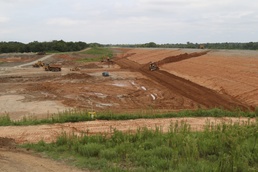
The Phase II contract was awarded in December 2016. During the ensuing 11 months, workers began repairs to the original structure by replacing the breach with additional fill material.
During each phase of the project materials from the original borrow areas were trucked in.
“We were very fortunate that the people who built the original structure back in 1940s stockpiled good impervious material from the original borrow sites, and the original haul roads and borrow areas were still accessible and intact, so we had good material sources,” Bilinski said.
Even with access to the original borrow areas, concerns about the presence of historical and culturally significant artifacts, as well as the potential for endangered wildlife in borrow areas.
These considerations not required during the levee’s construction in the 1940s but the Tulsa District addressed them by conducting archeological and wildlife surveys.
During Phase II of the tie in, lifts or layers of impervious material were placed and heavy equipment was used to compact each layer. Throughout the process engineers tested the materials and collected core samples to ensure the appropriate level of compaction was achieved. To maximize the available material the team utilized material from the cofferdam to tie the structure together, which resulted in a job in the completed repair portion.
“We had some concern during Phase II that we would run out of material from the original borrow areas and we were trying to address the question of ‘How do we get this repair completed without going over budget?’ due to the additional cost of identifying a new borrow site and trucking that material in,” said Bilinski.
To deal with the potential material shortage, the team decided to use material from the cofferdam, which was constructed with materials from the original borrow sites.
The resulting repair created a slight jog in the levee, which the team was able to accomplish because there was enough right of way for the structure.
Utilizing those borrow areas and incorporating the existing cofferdam saved taxpayers millions of dollars.
The original cost estimate for Phase II was more than $6 million compared to actual cost of approximately $2 million.
“We had a lot of lively discussions and differing opinions about how to accomplish this repair and what really strengthened my faith in the Corps of Engineers was the young engineers who were willing to stand up, think outside the box, and not accept the status quo,” Bilinski said. “I think we ended up with a tremendous product that everyone is confident in and is frankly better than the original structure.”