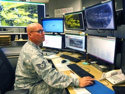
In a corner office of the Joint Typhoon Warning Center (JTWC), the Air Force’s Satellite Operations (SATOPS) department is hard at work ensuring the latest satellite technology is utilized for the tropical cyclone reconnaissance mission. At the forefront is Tech. Sgt. Matthew Drew, the Air Force’s Non-Commissioned Officer in Charge of the 17th Operational Weather Squadron’s Weather Flight at JTWC.
JTWC provides tropical cyclone reconnaissance, forecasts, warnings and decision support products to U.S. government agencies operating in the Pacific and Indian Oceans as directed by Commander, U.S. Pacific Command.
“The primary mission of the SATOPS department is to provide the crucial tropical cyclone reconnaissance support for U.S. Pacific Command, U.S. Africa Command and U.S. Central Command areas of responsibility,” said Drew. “Using satellite images alone, our task is to determine the intensity and position of tropical systems every three hours throughout the life of the storm. This is particularly challenging at night, when visible imagery is not available. We have recently created new enhancements using frequency bands outside of the visible spectrum to improve our operations. The new images help analysts distinguish between low-level and mid-level cloud features, enabling understanding the structure of the storm, resulting in improved position accuracy.”
“Minor errors in a tropical cyclone’s initial position and intensity are often amplified in forecast position and strength of the tropical cyclone,” explains Cmdr. Jillene Bushnell, JTWC’s commanding officer. “Our team is better equipped to improve forecast accuracy with the innovative enhancements Tech. Sgt. Drew rationalized. In turn, commanders will be provided the best forecast to make critical resource protection decisions as a tropical cyclone approaches.”
Drew pointed out that satellites are continually coming into and going out of service. Newer satellites offer improved technology with a broader range of channels, but replacement of aging satellites is not keeping pace with the loss of weather satellites with microwave and active wind sensing (scatterometry). Weather forecasters are facing serious challenges due to these losses.
“We recently experienced a loss of satellite coverage over the Indian Ocean as the European Meteosat-7 (launched in 1997) reached its end of life cycle this month,” said Drew. The European Meteosat-8 was moved to cover Africa to India, but we can no longer receive data over the Bay of Bengal and portions of the Southern Indian Ocean. “Our satellite image for the daily Indian Ocean bulletin showed this noticeable coverage gap in coverage. JTWC experimented with a number of solutions, ultimately resolving the gap by stitching together two Mercator projection satellite images – one from Meteosat-8 and the other from the Japanese Weather Satellite, Himawari-8. The resulting product provides a coherent satellite depiction of JTWC’s entire forecast area of responsibility.”
The new stitched image is available on JTWC’s website under the Indian Ocean Bulletin (ABIO) and western Pacific Bulletin (ABPW) at: https://metoc.ndbc.noaa.gov/jtwc.