HOUSTON - The projected path of Hurricane Ike was anything but a certainty. Televisions across the country displayed multicolored, segmented lines reaching like a rainbow of disjointed fingers from the center of the Gulf of Mexico to the surrounding coastal regions, fanning from New Orleans to Corpus Christi, Texas. Computer models and environmental sciences allowed some insight, but the Category 4 storm wasn’t following a road map.
By the time it entered the Gulf, Ike had claimed 83 lives, left thousands homeless and had registered as the costliest hurricane in Cuban history, racking up damages in excess of $7 billion on that island alone. On Sept. 11, 2008, that price tag went up exponentially.
With all the amazing advances in technology during the last century, modern science still can’t stop or prevent powerful storms like Ike from wreaking the havoc they’ve become infamous for. Instead, we’re left to prepare beforehand and recover the best we can in the wake. Proper planning requires up-to-date information and thanks to one agency, providing timely, accurate data on dangerous weather patterns is their day job.
The National Weather Service is a branch of the National Oceanic and Atmospheric Administration. They issue alerts concerning severe weather patterns perceived through a series of satellites, radar imaging systems and specialized sea buoys deployed to gather environmental data from in and around the continental U.S. and its outlying territories.
“Where we really earn our pay is when we’re able to issue warnings, giving people a heads up on potentially dangerous weather,” said Dan Reilly, Warning Coordination Meteorologist with the NWS in Houston. “If we have a particularly windy or dry day, we may issue a red flag warning alerting firefighters that conditions favor the development of wildfires. This would allow them to position their resources accordingly if anything were to occur.”
The same kind of watchful and responsive attitude is taken to tropical disturbances. On June 1, the beginning of hurricane season, the expert staff will turn their attention to the Atlantic. While the NWS hasn’t released their initial forecast on this year’s hurricane season, others have. According to the Extended Range Forecast produced by Philip J. Klotzbach and William M. Gray of Colorado State University, there’s a possibility we could see as many as 18 named storms and nine hurricanes develop in the Atlantic this season. That’s up from the average estimation of 12 named storms and 6.5 hurricanes. While it may be too early to say with certainty, Reilly agrees that the ingredients are coming together for a lively hurricane season.
“If there are warm waters in the tropical, equatorial waters of the Pacific, that leads to unfavorable conditions for the formation of a storm in the Atlantic,” said Reilly, breaking down the phenomenon commonly referred to as El Niño, a phenomenon that inhibits tropical storm formation. “This year we don’t have that. Also, the ocean waters of the Atlantic, where our storms form, it’s actually running above normal in the Caribbean and points east. That’s another factor.”
The prime ingredient for storm formation is warm water and while this is a scientific certainty there are still a great deal of calculations and models to run. Reilly believes that one thing is for certain.
“If we do get a storm that takes a more southern track into the Gulf, it’s going to make landfall,” said Reilly. “There’s just no way around it, because it’s surrounded by land.”
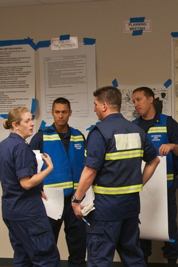
This is a reality that Coast Guard units all over the Gulf Coast prepare for year round. Most recently, Coast Guard and NWS members conducted a joint training exercise alongside other local and state agencies, simulating a Category 4 hurricane making landfall in the approximate area of Port Arthur, Texas.
“Exercises like this are part of a multi-year cycle of maintaining our absolute razor-edge of readiness,” said Capt. Brian Penoyer, prospective commander of Coast Guard Sector Houston/Galveston, set to take the helm on June 14. “Without exercises like this – in addition to other things we’re doing, reoccurring training and drills and so on – you never really reach that optimal state of readiness where you know exactly what you’re doing, where it’s a well oiled machine.”
“Really, one of the great virtues of the exercise for me was seeing not just what the Coast Guard does itself and how we prepare, but how we’re networked into a tightly woven community of not just private sector, but state and local entities who collectively make up the port. It was fantastic to see how well that relationship works,” said Penoyer.
Second only to their life-saving mission is the Coast Guard’s responsibility to the port. The Port of Houston is one of the busiest ports in the U.S., which has spawned the city of Houston, the fourth largest city in the U.S. In 2012, approximately $268 billion in exports traveled within the 25-miles of this massive port structure, making Texas the number one state for exports for the eleventh consecutive year.
If storm conditions were to cause unsafe conditions for the thousands of mariners and Houston port workers, or were to displace or destroy any of the Coast Guard’s aids to navigation, Penoyer would have the authority to either place restrictions on the waterway or close the port altogether. Having the responsibility over such a major piece of America’s economic equation in his proverbial backyard can be a little jarring, Penoyer admits, but with the team he’ll have around him, he stands confident.
“Considering the scope and scale of an area this busy, big and diverse, it’s a little overwhelming, frankly,” said Penoyer. “On the other hand, it’s very reassuring. Sector Houston/Galveston’s reputation precedes it. It’s one of the highest performing and most competent commands in the Coast Guard. The exercise for me was a great way for me to start getting my arms around that, helping me understand the culture down here a bit at a time.”
After making landfall just south of Galveston, the effects of Ike totaled 195 dead, $37.5 billion in damage and more than 3,000 pollution reports. Despite being one of the most destructive storms to touch the American coastline in decades, the recovery from Ike was expedient. What had taken nearly 10 years in post-Katrina New Orleans took less than half the time in Houston and Galveston. State and local agencies worked hand-in-hand with their federal partners to repair the damage done. This partnership shined when nearly 2,000 aids to navigation in the Houston Ship Channel, 90% of navigational markers in the waterway, were displaced or destroyed in the wake of Ike. The joint responders tackled the problem and eight days later had the ship channel reopened to traffic. The timely warnings, professional response and strong relationships had played their part in minimizing the effects of a very deadly force of nature.
With another potentially active hurricane season fast approaching, the NWS and Coast Guard conduct their usual drills, exercises and general preparedness, providing a strong example of readiness for local residents. Penoyer puts it best:
“We lead from the front.”