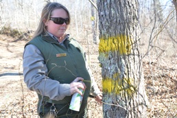
HENDERSONVILLE, Tenn. - The U.S. Army Corps of Engineers Nashville District Park Rangers at Old Hickory Lake and Lake Cumberland take pride in their work checking boundary markers, natural environmental protection areas and maintaining environmental wetlands around the Lake Cumberland and Old Hickory lakes.
As a part of the updated Shoreline Management Plan park rangers, Alan Earhart and Thomas Mason travel throughout the lake area to monitor boundary areas, enforce permits for docks, mowing and public use areas for more than 440 miles of shorelines at Old Hickory Lake.
“This is a great job because I enjoy nature and get to do my work outdoors,” said Earhart.
Earhart and Mason use maps provided by the district to locate and track boundary markers zigzagged through homes at the lake.
“This can be a tedious job but meeting and talking to many of the homeowners makes it a joy to do my job,” said Earhart.
At Lake Cumberland, park ranger Aurora Scott reminds recreational hunters and boaters of shoreline management and uses spray paint to identify tree line boundaries adjacent to land owners and for marking hunting areas near Wolf Creek Dam.
“It’s very important that we help assist in any way to help the public become aware of boundaries and markers on Corps property.
The Natural Resources Management mission is to manage and conserve those natural resources, consistent with ecosystem management principles, while providing quality public outdoor recreation experiences to serve the needs of present and future generations. Both Lake Cumberland and Old Hickory Lake are popular boating, camping and fishing sites for a variety of outdoor recreational activities. Recreational demands and developmental pressures increase each year, yet the total amount of public land and water area remains fixed.
“Some of these homeowners take pride in owning property on the lake or close enough that allows them to store a boat or fish so we make it our business to provide them with accurate information and show courtesy when we are out here checking boundaries or providing a service,” said Earhart.
To do this at these large areas, the rangers work closely with communities surrounding the lakes to protect and enhance the scenic, recreational and environmental resources the lake offer.
They also help maintain the Corps' ability to manage flood conditions on each lake by enforcing easement and construction standards specific to each lake.
The Shoreline Management Plan provides policies and guidelines for the effective long-range management of the shoreline resource. The Natural Resources Management mission is to manage and conserve those natural resources, consistent with ecosystem management principles.
“Managing our use and development of shorelines is very important,” said Scott. “It helps us to preserve what we value and protect life and property. Because sharing and caring for shorelines is everyone’s responsibility."
For more information pertaining to the the Shoreline Management Plan, contact the Old Hickory resource manager’s office, the Lake Cumberland Resource office or visit the web at www.lrn.usace.army.mil/Locations/Lakes/LakeCumberland.aspx.