NOGALES, Ariz., - A detachment from Engineer Company, Marine Wing Support Squadron 272, based at Marine Corps Air Station New River, N.C., departed Feb. 28 to Nogales, Ariz., to construct a new border security road and improve several existing roads in support of the U.S. Customs and Border Protection’s Southwest Border Infrastructure Enhancement Program.
Since the dawn of man, there has been property. From cavemen calling caves home to modern people looking for a slice of the American dream.
Drafters and surveyors have mapped out the terrain and set the foundation for everything from the Great Pyramids of Giza to the new One World Trade Center in New York City.
A detachment from Engineer Company, Marine Wing Support Squadron 272, based at Marine Corps Air Station New River, N.C., departed Feb. 28 to Nogales, Ariz., to construct a new border security road and improve several existing roads in support of the U.S. Customs and Border Protection’s Southwest Border Infrastructure Enhancement Program.
The ongoing project is phase three of a multi-year engineer support operation designed to enhance the U.S. Border Patrol – Tucson Sector’s ability to counter transnational criminal activities being conducted along the U.S./Mexico border in Southern Arizona. The project site is located amidst a well-known illicit drug and illegal alien smuggling corridor.
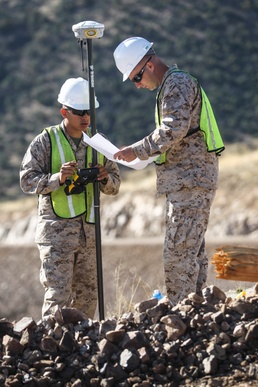
The drafter and surveyor Marines were tasked with marking and plotting exactly where the other Marines needed to add or remove from the road.
“The surveyor Marines are very important,” said Staff Sgt. Donald E. Stehley, MWSS-272 detachment staff noncommissioned officer-in-charge. “Without them we would not know exactly where our left and right lateral limit is, and in a job like this, that is very important.”
The Marines are trained with AutoCAD and a GPS-based tracking system that can pinpoint the exact position of the remote unit, said Cpl. Joe Sabun, MWSS-272 surveyor.
The ground unit is calibrated to the exact location the survey Marines are working in, and by using the pre-loaded maps on it, they can use the roving unit to measure the ground, said Lance Cpl. Gill Aluna, MWSS-272 surveyor.
The surveyors are also the first people on a construction site, Sabun said. They create the foundation to build a road, a structure or anything that is constructed.
The surveyors methodically marked and placed posts every 50 feet to guide the Marines in the earth-moving machines down the rocky terrain. The stakes in the ground contain detailed information about the progress and limits of the specific location. The Marines in the machines were told that the stakes were the lateral limits or they were offset by a few feet. That way the Marine could adjust their construction accordingly. They also mark the posts with coded information, so that any contractor who looks at it can understand why the post is there.
With the guidance and outlines of the surveyor Marines, MWSS-272 detachment is ahead of schedule and is expected to return to the air station near the middle of April.